Before going in details of the world map, we will go through few basics...
1. The Earth's surface is made up of a series of large plates (like pieces of a giant jigsaw puzzle).
2. These plates are in constant motion travelling at a few centimetres per year.
3. The ocean floors are continually moving, spreading from the centre and sinking at the edges.
4. Convection currents beneath the plates move the plates in different directions.
5. The source of heat driving the convection currents is radioactive decay which is happening deep in the Earth.
6. The edges of these plates, where they move against each other, are sites of intense geologic activity, such as earthquakes, volcanoes, and mountain building.
The Tectanic plates are categorised as 7 major and few minor plates.
These seven major plates comprise the bulk of the seven continents and the Pacific Ocean.
 Europe - 47

 Source - http://www.worldatlas.com/cntycont.htm
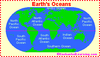
Did you ever think how this earth has formed....? I am very curious and I think Every one is very curious to know how this earth was formed with seven continents (why only seven...?) and with world oceans called Pacific, Atlantic, Indian, Southern (Antarctic), and Arctic Oceans...?
There was a hypothesis by Wegner that, the continents had once formed a single landmass(called Pangea) before breaking apart and drifting to their present locations and later this was explained with 'Plate Tectonics' theory i.e the concept the movements these continents through Tectanic Plates.
As per the Tectanic Plate theory:There was a hypothesis by Wegner that, the continents had once formed a single landmass(called Pangea) before breaking apart and drifting to their present locations and later this was explained with 'Plate Tectonics' theory i.e the concept the movements these continents through Tectanic Plates.
1. The Earth's surface is made up of a series of large plates (like pieces of a giant jigsaw puzzle).
2. These plates are in constant motion travelling at a few centimetres per year.
3. The ocean floors are continually moving, spreading from the centre and sinking at the edges.
4. Convection currents beneath the plates move the plates in different directions.
5. The source of heat driving the convection currents is radioactive decay which is happening deep in the Earth.
6. The edges of these plates, where they move against each other, are sites of intense geologic activity, such as earthquakes, volcanoes, and mountain building.
The Tectanic plates are categorised as 7 major and few minor plates.
These seven major plates comprise the bulk of the seven continents and the Pacific Ocean.
1. African Plate
2. Antarctic Plate
3. Eurasian Plate
4. Indo-Australian Plate
5. North American Plate
6. Pacific Plate
7. South American Plate
Total Number of Continents - 07 (They are generally identified by convention rather than any strict criteria)
1. Asia 2. Africa 3. Europe 4. South America 5. North America 6. Australia 7. Antarctica
1. Asia 2. Africa 3. Europe 4. South America 5. North America 6. Australia 7. Antarctica
The no.of countries listed by Conntinent:
Asia - 44
Africa - 54
Oceania - 14 (Includes Australia and proximate islands)
South America - 12
North America - 23
Total = 194 ( Countries recognized by United Nations)
Note: (Regarding England, Scotland and Wales, though considered individual countries, they are all a part of the United Kingdom (UK), a European country.