Friday, 24 August 2012
Suez Canal - A shortcut for Britishers to DRAIN Indian wealth
 The Suez Canal also known by the nickname "The Highway to India"
- The distance between Mumbai and London is roughly 6,200 nautical miles using the Suez Canal and 10,800 nautical miles taking the longer route around the Cape of Good Hope.
- The opening of the Suez Canal in 1869 reduced transport costs and thus made the exploitation of the Indian market easier:
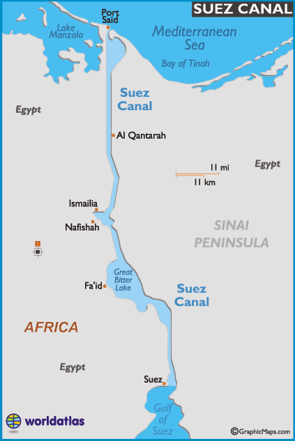
- It opened in November 1869 after 10 years of construction work, it allows transportation by water between Europe and Asia without navigation around Africa.
- The canal is owned and maintained by the Suez Canal Authority (SCA) of Egypt.
Note: Under international treaty, it may be used "in time of war as in time of peace, by every vessel of commerce or of war, without distinction of flag.
- About 7.5% of world sea trade is carried via the canal today. In 2008, a total of 21,415 vessels passed through the canal and the receipts from the canal totaled $5.381 billion with the average cost per-ship at roughly $251,000
Environmental Impact:
- The opening of the Suez Canal in 1869 created the first salt-water passage between the Mediterranean and Red seas. Although the Red Sea is about 1.2 m (4 ft) higher than the eastern Mediterranean, the current between the Mediterranean and the middle of the canal at the Bitter Lakes flows north in winter and south in summer.
- The current south of the Bitter Lakes is tidal, varying with the height of tide at Suez.
- The Bitter Lakes, which were hypersaline natural lakes, blocked the migration of Red Sea species into the Mediterranean for many decades, but as the salinity of the lakes gradually equalised with that of the Red Sea, the barrier to migration was removed, and plants and animals from the Red Sea have begun to colonise the eastern Mediterranean.
Note: This migratory phenomenon is called Lessepsian migration or Erythrean invasion.
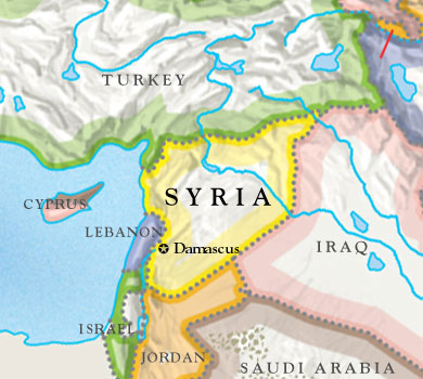
Suez Canal - Surrounding countris
Monday, 6 August 2012
South America - Part 1 ( Countries)
In this post, I will explain you how to remember and locate the countries in South America.
South America, the planet's 4th largest continent, includes (12) independent countries and (3) major territories; the Falkland Islands, Galapagos Islands and French Guiana.
 The continent contains :
1. World's highest waterfall, Angel Falls in Venezuela;
2. The largest river (by volume), the Amazon River;
3. The longest mountain range, the Andes, and
4. The driest place on earth, the Atacama Desert in Chile.
( I will explain this in details in the next post)
Remember the below sentance to identify the list of sovereign states and dependent territories in South America:
Ecuador’s Curriculum Vitae Got Selected BeFore Plan ACcepted by Union Public Board
Ecuador’s Curriculum Vitae Got Selected BeFore Plan ACcepted by Union Public Board
 E - Ecuador
G - Guyana
S - Suriname
B - Brazil
S - Suriname
B - Brazil
F - French Guiana
P - Peru
A- Argentina
C - Chile
P - Paraguay
U - Uruguay
P - Peru
A- Argentina
C - Chile
P - Paraguay
U - Uruguay
B - Bolivia

Just play the below game for 4 to 5 five to get familier with Countries
I hope this will help you to remember atleats few of the countries of SA.
Note: Also have a look at the islands and oceans surroundedwhile identifying the countries.
Source: Worldatlas.com

Thursday, 2 August 2012
Venezuela joined Mercosur Trade Bloc on July 31,2012
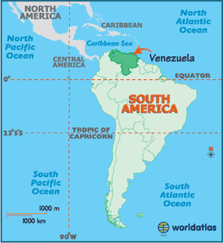
Recently on 31 July 2012, South American country ‘ VENEZUELA’ joined MERCOSUR trade bloc.
1. Venezuela had signed a membership agreement on 17 June 2006 (but its accession was blocked by the Senate of Paraguay)
2. Full membership for Venezuela became effective on 31 July 2012.
3. Paraguay is suspended from Mercosur on 22 June 2012 for the violation of the Democratic Clause of Mercosur i.e Impeachment of Fernando Lugo.
Country :Venezuela
Capital: Caracas
Country :Venezuela
Capital: Caracas
Government:Federal presidential constitutional republic
President:Hugo Chávez
Vice President:Elías Jaua
National language:Spanish
Venezuela has some of the largest oil and natural gas reserves in the world, and consistently ranks among the top ten world crude oil producers.
For more details:
advantages-disadvantages-MERSOCUR-membership:

The Asuncion Treaty is based on the doctrine of the reciprocal rights and obligations of the member states.
Its purpose is to promote free trade and the fluid movement of goods, people, and currency.
Objectives:
1. The free transit of produced goods, services and factors among the member states. Among other things, this includes the elimination of customs rights and lifting of nontariff restrictions on the transit of goods or any other measures with similar effects;
2. Fixing of a common external tariff (CET) and adopting of a common trade policy with regard to nonmember states or groups of states, and the coordination of positions in regional and international commercial and economic meetings;
3. Coordination of macroeconomic and sectorial policies of member states relating to foreign trade, agriculture, industry, taxes, monetary system, exchange and capital, services, customs, transport and communications, and any others they may agree on, in order to ensure free competition between member states;
4. The commitment by the member states to make the necessary adjustments to their laws in pertinent areas to allow for the strengthening of the integration process.


About MERCOSUR :
Source:wikipedia.org
Wednesday, 25 July 2012
Introductory Post - Earth Formation and Continents
Before going in details of the world map, we will go through few basics...
1. The Earth's surface is made up of a series of large plates (like pieces of a giant jigsaw puzzle).
2. These plates are in constant motion travelling at a few centimetres per year.
3. The ocean floors are continually moving, spreading from the centre and sinking at the edges.
4. Convection currents beneath the plates move the plates in different directions.
5. The source of heat driving the convection currents is radioactive decay which is happening deep in the Earth.
6. The edges of these plates, where they move against each other, are sites of intense geologic activity, such as earthquakes, volcanoes, and mountain building.
The Tectanic plates are categorised as 7 major and few minor plates.
These seven major plates comprise the bulk of the seven continents and the Pacific Ocean.
 Europe - 47

 Source - http://www.worldatlas.com/cntycont.htm
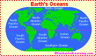
Did you ever think how this earth has formed....? I am very curious and I think Every one is very curious to know how this earth was formed with seven continents (why only seven...?) and with world oceans called Pacific, Atlantic, Indian, Southern (Antarctic), and Arctic Oceans...?
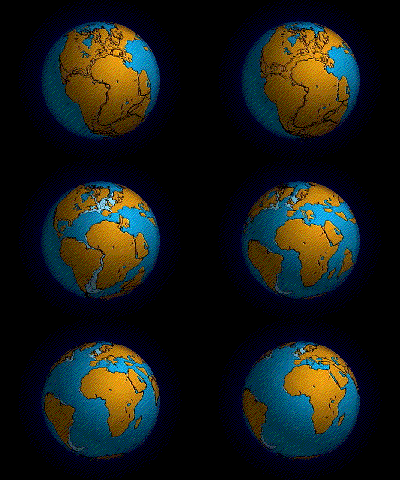
There was a hypothesis by Wegner that, the continents had once formed a single landmass(called Pangea) before breaking apart and drifting to their present locations and later this was explained with 'Plate Tectonics' theory i.e the concept the movements these continents through Tectanic Plates.
As per the Tectanic Plate theory:There was a hypothesis by Wegner that, the continents had once formed a single landmass(called Pangea) before breaking apart and drifting to their present locations and later this was explained with 'Plate Tectonics' theory i.e the concept the movements these continents through Tectanic Plates.
1. The Earth's surface is made up of a series of large plates (like pieces of a giant jigsaw puzzle).
2. These plates are in constant motion travelling at a few centimetres per year.
3. The ocean floors are continually moving, spreading from the centre and sinking at the edges.
4. Convection currents beneath the plates move the plates in different directions.
5. The source of heat driving the convection currents is radioactive decay which is happening deep in the Earth.
6. The edges of these plates, where they move against each other, are sites of intense geologic activity, such as earthquakes, volcanoes, and mountain building.
The Tectanic plates are categorised as 7 major and few minor plates.
These seven major plates comprise the bulk of the seven continents and the Pacific Ocean.
1. African Plate
2. Antarctic Plate
3. Eurasian Plate
4. Indo-Australian Plate
5. North American Plate
6. Pacific Plate
7. South American Plate
Total Number of Continents - 07 (They are generally identified by convention rather than any strict criteria)
1. Asia 2. Africa 3. Europe 4. South America 5. North America 6. Australia 7. Antarctica
1. Asia 2. Africa 3. Europe 4. South America 5. North America 6. Australia 7. Antarctica
The no.of countries listed by Conntinent:
Asia - 44
Africa - 54
Oceania - 14 (Includes Australia and proximate islands)
South America - 12
North America - 23
Total = 194 ( Countries recognized by United Nations)
Note: (Regarding England, Scotland and Wales, though considered individual countries, they are all a part of the United Kingdom (UK), a European country.
Subscribe to:
Posts (Atom)